odp
73 to 96 of 299 locations
-
Asschatterkeerkade
Asschatterkeerkade
The Asschatterkade dates from 1745, and is one of the longest trenches of the Grebbelinie, with its length of 2500 metres. The trench from 1799 lies east of Leusden, at the edge of the flood plain. But there are also elements from more recent history which can be found.
The nine visible military bunkers, for example, were built during the mobilisation between 1939-1940. There is also a unique concrete tank barrier from this time. During the May Days of 1940, the Germans attempted in vain to break through the defences.
Hagenouwselaan 0
3831 JP Leusden -
Brasserie Soesterduinen
Brasserie Soesterduinen Soesterbergsestraat 188
3768 MD Soest -
Delicacies from Zeist
Delicacies from Zeist Centrum Zeist
3701 Zeist -
De Hooge Vuursche Castle
De Hooge Vuursche Castle Hilversumsestraatweg 14
3744 KC Baarn -
Café-Restaurant De Lage Vuursche
Café-Restaurant De Lage Vuursche Dorpsstraat 2
3749 AD Lage Vuursche -
Fort de Batterijen
Fort de Batterijen Fort De Batterijen
Overeindseweg 25
3439LP Nieuwegein -
Museum Castle Amerongen
Museum Castle Amerongen Kasteel Amerongen
Drostestraat 20
3958 BK Amerongen -
Grote Kerk Vianen (Great Church)
Hubrecht van Vianen founded a chapel in the 13th Century. It fell under the mother church in Hagestein and began growing fast. In the year 1345, it became a parish church and was granted marriage and burial rights. For this, a sum of money had to be paid to the church in Hagestein annually. In the 14th Century, the chapel was replaced by a single-nave church. In the year 1433, following a feud between Vianen and Hagestein, the Bishop of Utrecht decided to split the two churches.
In the mid-15th Century, the church was replaced by a 3-aisle Gothic hall church which is the same size as the current church. (Including the tower, it’s 77.5 metres long, 43 metres wide and 41 metres high.) Since the church also contains the family graves of the Lords of Vianen, it was required to match the grand status of the Brederodes in terms of its size and appearance.
After a fire in the year 1540, the church (de Grote Kerk) was rebuilt in its current form almost immediately (as a combination of a hall church and cruciform church) with the support of Reinoud III van Brederode. The church became Reformed under his son, Hendrik van Brederode. On 25 September 1566, the Roman Catholic institution disappeared and then, on 1 October, the first Protestant service was held.
Discover all monuments in Vianen. Grote kerk Vianen
Voorstraat 110
4132 AT Vianen -
Pannenkoekenhuis de Grebbeberg
Pannenkoekenhuis de Grebbeberg Grebbeweg 101
3911 AV Rhenen -
Fort Werk aan de Groeneweg
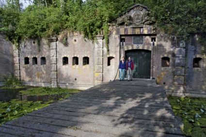
Walking through the historic trenches of Werk aan de Groeneweg is like a walk back in time. The defence structure still has its original configuration. The infantry set-up in World War One consisted of a double trench with earthen walls, 55 group shelters and lovely fruit trees.
The grounds are a fantastic playground for children. You can have a great time here roaming around, crawling through a trench, playing hide and seek and participating in an exciting search and experience walk of about 2 km, with soldier Vendrik as your guide.
Groeneweg
3998 Schalkwijk -
The Green House
The Green House Schothorsterlaan 21
3822 NA Amersfoort -
Werk aan het Spoel
Werk aan het Spoel
In 1815, a fan lock was built into the Lekdijk near Goilberdingen for inundation purposes. It was protected by an earthen battery. In 1848, the battery was upgraded to a fort. Later on, the inundation system was optimised, and four bomb-proof buildings were added to the fort. In peacetime, the road on top of the dyke ran right through the fort, but traffic was led around the fort in times of mobilisation. In 1939, seven concrete shelters and two machine gun casemates were added. An unusual feature is the high free-standing wall in a field to the south of the fort. This was the stop butt of a German firing range.
Goilberdingerdijk 40
4106 LC Culemborg -
Geofort
Geofort
Explore the exciting old fort island at GeoFort. Plenty of experiments await both inside and outside: wander the dark subterranean tunnels, make your way through the maze or use the lift to descend 6,000 kilometres into the earth. Use the maps to find your way around the virtual Minecraft world or visit the virtual sandpit, where you can make a volcano erupt! Feel like having a break? Our pancake restaurant, De WereldPan, has an extensive food and drinks menu.
Geo
Geofort
Nieuwe Steeg 74
4171 KG Herwijnen -
Sterkenburg Castle
Sterkenburg Castle Langbroekerdijk 10
3972 ND Driebergen-Rijsenburg -
TOP Museum Spakenburg
TOP Museum Spakenburg Zuiderzeekade
Spakenburg -
Breukelen
Breukelen Breukelen
-
Large Pump/Vianen Town Pump
Large Pump/Vianen Town Pump Stadspomp Vianen
Voorstraat 54
4132 AS Vianen -
Canals and shipyards
The Utrecht canals with their wharves and wharf cellars are unique in the world.
The 12th Century Oudegracht was built to change the course of the Oude Rijn river. Connecting the river Vecht in the north to the Vaartsche Rijn in the south, the Oudegracht was destined to become an elongated harbour. Large city castles were built along the canal and in the 13th Century, shipyards were built as second streets at water level. The deep cellars, serving as storage spaces, ran through to below the houses. Today, the canals and shipyards are home to shops, restaurants and private residences.
Oudegracht 0
3511 AZ Utrecht -
National Military Museum
National Military Museum Verlengde Paltzerweg 1
3768 MX Soest -
Restaurant-Chalet Klein Zwitserland
Restaurant-Chalet Klein Zwitserland Traaij 295
3971 GM Driebergen-Rijsenburg -
Molen de Ster
Molen de Ster Utrecht
-
Stayokay hostel Utrecht-Bunnik
Stayokay hostel Utrecht-Bunnik Rhijnauwenselaan 14b
3981 HH Bunnik -
Volmolen
Volmolen De Volmolen
Plantsoen Noord 2
3811 GH Amersfoort -
Restaurant Rederij De Eemlust
Restaurant Rederij De Eemlust Eemweg 72
3741LC Baarn